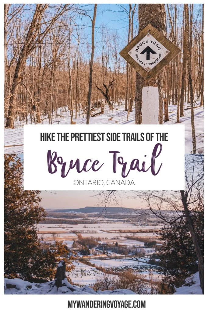
Hiking the Bruce Trail: 14 incredible side trails to explore
The Bruce Trail is Ontario’s most famous trail. Following the Niagara Escarpment, it weaves nearly 900 kms from Niagara to Tobermory. Hiking the Bruce Trail end to end has been on my bucket list for years, but it takes about a month. The side trails offer a taste of what the main trail is like, and it provides ample opportunity to explore some of Ontario’s best natural history.
What is the Bruce Trail?
The 900-kilometre trail runs from Queenston near Niagara Falls to the tip of the Bruce Peninsula near Tobermory. It is the oldest and longest marked hiking trail in Canada (if you don’t count the Trans Canada Trail).
It’s also one of the most accessible trails, with a large chunk of Ontario’s population living within an hour of an access point. The Bruce Trail, and its 400 km of side trails, run through a UNESCO World Biosphere Reserve, is some of the most exciting landscapes in Ontario.

The escarpment is like a giant scar that cuts one part of the province from the other. Despite popular belief, the escarpment was not caused by a fault line, but the result of erosion. Here you’ll find one of the oldest forest ecosystems on this side of North America.
The Bruce Trail is split into nine clubs that maintain the trail and organize events. You don’t have to be a Bruce Trail Conservatory or individual club member to access and hike the Bruce Trail.
How to find the side trails near you

The best way to hike the Bruce Trail is to pick up a Bruce Trail Reference Map. This large guide book has detailed maps on each section of the trail, trail description, parking locations and other essential details. It costs about $45. The 31st edition was published in Aug. 2023 and you can pick up online or in most Ontario bookstores. If you’re eager and want the maps to be the most updated, you can purchase the Bruce Trail app for iOS or Android for $2.99/month or $29.99/year.
Wayfinding on Bruce Trail Side Trails

Now that you’re an eager beaver and ready to head out on the trails, make sure you know how to follow them. Much of the trail is in the bush, and it can be easy to lose your way if you’re not paying attention.
The Bruce Trail is marked with long rectangular blazes either on trees, fence posts, stiles or rocks. A blaze should be visible from a previous blaze, so you’ll always be able to see where you are headed.
A single blaze means straight ahead. To indicate a turn, there will be two rectangular blazes on top of one another. If the top blaze is on the left of the bottom blaze, it means to go left. If the top blaze is on the right of the bottom blaze, it means to go right.
All of the side trails are marked with blue blazes. And a blue T shape blaze means the side trail has ended.
What you need to know about hiking the Bruce Trail

The Niagara Escarpment is home to hundreds of species of plants and animals. Unfortunately, some are more dangerous than others. Poison Ivy is common along the trail, and it can cause itching or a skin reaction. The Bruce Trail Conservatory recommends washing immediately with soap if you come in contact, but hand sanitizer is a good first-aid measure.
Rattlesnakes and bears are also common in the Bruce Peninsula, so you’ll want to read up on these types of wildlife encounters before hitting the trails.
Lastly, make sure you know the hiker’s code:
Hike only along marked routes. Do not take shortcuts
Do not climb fences. Use the stiles
Respect the privacy of people living along the trail.
Leave the trail cleaner than you found it. Carry out all litter.
Use a portable stove. No open fires are allowed on the trail.
Camp only at designated campsites.
Leave flowers and plants for others to enjoy.
Do not damage live trees or strip off bark.
Keep dogs on a leash and under control at all times.
Do not disturb wildlife.
Leave only your thanks and take nothing but photographs
Obey all signs.
What you need for a day trip on the trails
Before setting off to hike the Bruce Trail, make sure you have what you need for a comfortable day hike.
Hiking essentials
Water - You need to have plenty of water. Think 1 litre per person, and 3 litres in the summer. You can get a handy bladder, like this one, making it easier to carry and to drink from while on the go.
First aid kit - From blisters to insect bites to cuts, scrapes and more severe injuries, you’ll want a simple first aid kit to bring with you on all outdoor outings.
Food - You’re going to be burning a lot of calories on longer hikes, so make sure to pack a decent amount of food that will help you replace those calories. I love sandwiches, granola bars and stuff made with peanut butter.
Navigation
Map - Bring a map, paper maps will never not be useful, plus it will give you a marker in case there is an emergency. I like to carry my maps in a waterproof document bag that I attach to my bag with a carabiner.
Compass - Being able to read a compass is genuinely a skill you’ll want in your brain’s toolbox. You never know when the time might come when you’ll need it. Plus, knowing that you’re headed in the right direction gives you a sense of relief when on the trails
Protection from the elements
Sunscreen - Wear sunscreen all the time. It’s common sense.
Insect repellent - In the summer, the bugs are going to get bad. You’re hiking in an old forest, where there are annoying mosquitoes and blackflies. You can help the situation by wearing proper clothing, but insect repellent also helps
Buff - Buffs (which is a brand of a versatile scarf) can be used in multiple ways. You can protect your nose and mouth from the cold, wear it as a headband or as a balaclava.
Hat - Keeps the sun out of your eyes and protects your forehead from getting burnt.
Sunglasses - Block that sun and protect your eyes!
Moisture-wicking clothing - Whether you’re hiking in the summer or the winter, you’ll want to wear clothing that has moisture-wicking technology. The worst condition you could be in on the trails is wet.
RELATED: Day Hiking Essentials
Other hiking essentials
Day pack - To carry all these essentials, you’ll want a decent daypack that will be comfortable for a full outing. So while I love packable day packs you can bring on trips abroad, something more structured would be better. I like my dad’s old Arcteryx day pack. It’s got a water bladder holder, is water repellent and has lots of room for the necessary items. And most importantly, it's lasted over 20 years.
Hiking boots - Hiking boots are something you’re going to want to go into a store to test out. I tend to get crazy blisters with certain new shoes, so I want to test them out and break them in before heading out on the trail. My Solomons have held up so well, but there are so many great brands out there. Do your research and test them before buying. (I like buying at MEC due to their stellar return policy).
Trekking poles - they are super helpful when navigating slippery or uneven pathways. Trekking poles also help alleviate the strain on your back and knees. You can get collapsible ones that you can attach to your day pack with a durable carabiner.
Knife - a multi-use pocketknife is a handy tool, so pack one if you think it’s necessary.
Headlamp - There are caves that you can explore on the Bruce Trail, so bring your headlamp for those darker spots. Also, if you’re going on a longer trek, you might want to have one for backup in case it gets darker before you expect it to.
The Best Bruce Trail side trails to hike
With over 400kms of side trails to choose from, hiking the Trail can be daunting. Here are some of the best side trails for you to start with.
Tiffany Falls Side Trail
Section of the trail: Iroquoia Club, near Hamilton
Length: 420m
Where to Park: Located at Tiffany Falls Conservation Area, at the 45km mark. Parking is $5 per day.
The best part about this Bruce Trail Side Trail: This is a short trail, although you’ll be going uphill most of the way. But the payload is worth it. At the end of this side trail, you’ll come across Tiffany Falls, a delightful 21-metre high cascade waterfall.
Dundas Lookout/ Tews Falls Side Trail

Section of the trail: Iroquoia Club, near Hamilton
Length: 2.9km
Where to Park: During the winter, you can park at Spencer Gorge Conservation Area at Tews Falls, but during summer and fall, when colours are at their peak, you’ll have to park at Christie Lake Conservation Area. It costs $10 per vehicle and another $5 entry fee. Alternatively, you could park at the Sydenham Lookout Side Trail at 58.6km and hike the mostly uphill trek from the bottom of the escarpment to the top.
The best part about this Bruce Trail Side Trail: This lookout is famous for a reason. Dundas Peak offers incredible views of the Dundas Valley and Spencer Gorge. In the warmer months, it can be pretty busy, but these views are worth it.
Mount Nemo Side Trail

Section of the trail: Iroquoia Club, near Burlington
Length: South Loop is 1.8km, North Loop is 3.3km
Where to Park: At Mount Nemo Conservation Area near the 91.7km mark. Entrance is $7 per person
The best part about this Bruce Trail Side Trail: Mount Nemo has some pretty stellar views, but what I love most about it is thatyou start and end at the top of the escarpment, there are no steep sections orstairs (I hate stairs), and you can easily spend an afternoon here exploringthe crevices and viewpoints.
Crawford Lake Side Trail

Section of the trail: Iroquoia Club, near Milton
Length: Woodland Trail is 1.5km, Escarpment Trail is 2.4 km, and Crawford Lake Trail is 1 km
Where to Park: Crawford Lake Conservation Area, entrance is $7.75 per person.
The best part about this Bruce Trail Side Trail: I used to be afraid of Crawford Lake. When I was a kid, we came here for a school trip, and I remember being told a scary story about the Meromictic Lake, where there’s no oxygen at the bottom because it’s so deep, so it preserves everything down there. But I came back and enjoyed the easy trails through the forest and the boardwalk around Crawford Lake.
Rattlesnake Point Side Trail

Section of the trail: Iroquoia Club, near Milton
Length: Rattlesnake Point Side Trail 2.5km one way, Vista Adventure Trail is 1.5km
Where to Park: At Rattlesnake Point Conservation Area; entrance is $7.
The best part about this Bruce Trail Side Trail: Rattlesnake Point is an awesome place. I used to rock climb here as a kid because it’s got an awesome cliff face for climbing. But if you’re just looking to hike the Bruce Trail, then you can start at the parking lot of the conservation area and take the Vista Adventure Trail to the lookout. Continue along the side trail, which follows the escarpment, all the way back to the main Bruce Trail at the 110.9km mark
Cheltenham Badlands Side Trail

Section of the trail: Caledon Hills Club, near Caledon
Length: 360m
Where to Park: Cheltenham Badlands parking lot (limited parking from May to October only), entrance is $10. If the parting lot is full, you can park at Terra Cotta Conservation Area and take a shuttle
The best part about this Bruce Trail Side Trail: The Cheltenham Badlands is one of the most stunning landscapes in Ontario. The rusty red soil and the eroded waves of land make it look like something from Mars. The badlands have gone through quite a bit of transformation over the years, and you are no longer allowed to walk on the fragile ecosystem. To get to the viewpoint, you follow the Bruce Trail for a short distance, then join onto the Cheltenham Badlands Side Trail to the boardwalk, where you’ll have ample viewing spots.
The Ring Kiln Side Trail

Section of the trail: Caledon Hills Club, near Forks of the Credit
Length: 600m
Where to Park: On Highway 11 just past Chisholm Street, near the 8.8km marker, free
The best part about this Bruce Trail Side Trail: The Ring Kiln Side Trail is pretty cool since it follows old rail beds to the ruins of Hoffman lime kiln. The huge stone rocks are hidden in the dense forest until you happen upon them. The industrial powerhouse was constructed back in the late 1800s and had 12 kilns making lime for agriculture. You can even explore the structure that held the giant smokestack.

Carriage Side Trail/ Spillway Trail
Section of the trail: Dufferin Hi-Land Club, near Shelburne
Length: Carriage Side Trail is 1.3km, and the Spillway Trail is 1.3km.
Where to Park: At Mono Cliffs Provincial Park, $11 to park
The best part about this Bruce Trail Side Trail: The Carriage Side Trail takes you through a lovely forested area towards the cliffs. Take the Spillway Trail to walk along the boardwalk through an old canyon spillway or take the stairs up to the top of the cliff and join the main Bruce Trail. Further along the main trail, also known as the McCarston’s Lake Trail, you’ll come to a viewing platform overlooking the valley.
Splitrock Narrows Nature Reserve Side Trail
Section of the trail: Dufferin Hi-Lands Club, near Shelburne
Length: 1.9km
Where to Park: A small parking lot off of 2nd Line EHS, free
The best part about this Bruce Trail Side Trail: Splitrock Narrows is underrated. Here you hike through exposed escarpment and views over the forest; there’s even a 12-foot deep chasm that you can explore… if you’re brave enough.
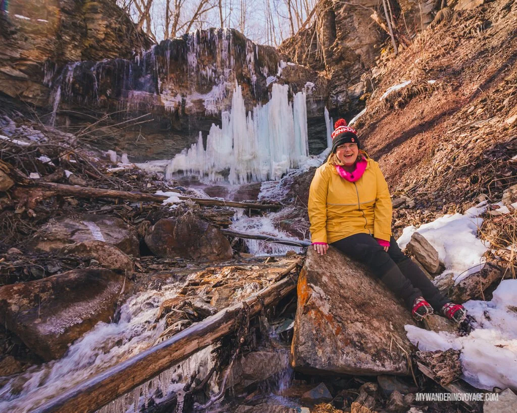
Stew Hilts Side Trail

Section of the trail: Beaver Valley Club, near Eugenia
Length: 460m
Where to Park: A small parking lot off Johnson Sideroad, free
The best part about this Bruce Trail Side Trail: This new side trail leads you down further into Beaver Valley and to the base of Hilts Falls. In the winter, the falls freeze over, creating something right out of the movie Frozen. While this side trail is awesome, heading down into Beaver Valley, what goes down, must come up. The hike back up the valley can be exhausting.
RELATED: Why you Should use a Hiking Log for your Adventures
Spirit Rock Side Trail
Section of the trail: Peninsula Club, near Wiarton
Length: 3.2km,
Where to Park: Spirit Rock Conservation Area, entrance is $6
The best part about this Bruce Trail Side Trail: This site used to be the home of the Alexander McNeill estate in the late 1800s, but his family mishandled the money after his death, and the mansion was abandoned. Today it’s a stone shell, but you can still explore it nonetheless. At the tip of the loop, there is the Spirit Rock Lookout over Colpoy’s Bay and a spiral staircase where you can climb down the cliff face and rejoin the main BruceTrail.
The Cotswold Way - Bruce Trail Friendship Trail
Section of the trail: Peninsula Club, near Lion’s Head
Length: 7.2 km (only 5.4km if you take the MooreStreet Side Trail)
Where to Park: McCurdy Drive Parking Lot off of Moore Street, free
The best part about this Bruce Trail Side Trail: While technically not a side trail, this section of the Bruce Trail is called a Friendship Trail. What does that mean? Well, this portion is “twinned” with The Cotswold Way, a 162-km national trail in England. Here in Canada, this section of the Bruce Trail brings you through caves and potholes before you stumble upon Lion’s Head Lookout, a famously beautiful part of the Bruce Peninsula.
RELATED: 22 best scenic bridges in Ontario you have to visit
Geodetic Side Trail
Section of the trail: Peninsula Club, near Lion’s Head
Length: Inland Side Trail to Geodectric Side Trail and back to Lion’s Head is approximately 4km
Where to Park: McCurdy Drive Parking Lot off of Moore Street, free
The best part about this Bruce Trail Side Trail: While you’re at Lion’s head, you might as well take the Inland Side Trail to the Geodetic Side Trail. Why? Because at the end of the Geodetic Side Trail is a marker on the ground denoting the 45th North Latitude, the halfway mark between the North Pole and the equator, which is pretty darn cool.
Burnt Point Side Trail

Section of the trail: Peninsula Club, near Tobermory
Length: 3.6km
Where to Park: At the Bruce Peninsula National Park visitor centre, $11.70 during the warmer months, free during the winter.
The best part about this Bruce Trail Side Trail: At nearly the end of the Bruce Trail, at the 163.8km marker, the Burnt Point Side Trail takes you away from the Main Trail to Dunks Point, a beautiful spot overlooking Georgian Bay. You’ll also get incredible views of Little Dunks Bay and Flowerpot Island in the distance.

Being outside, whether you’re by yourself, with loved ones or in a group, can be absolutely healing. Nature is excellent that way. Take this moment to enjoy the great outdoors by hiking the Bruce Trail on these side trails.


![Everything you need to know about Pukaskwa National Park [+ hiking guide]](https://images.squarespace-cdn.com/content/v1/6495d3b60f950e6c0e7c842f/1687544873523-A8Z7P3OTJ503YPBVEG7C/guide-to-pukaskwa-national-park.jpg)


From hiking all the incredible trails, to stargazing in some of Canada’s darkest skies, to enjoying all the scenic views, there are so many amazing things to do at Lake Superior Provincial Park where you can discover Ontario’s superior wilderness!